
What to do
Activities in the surroundings.
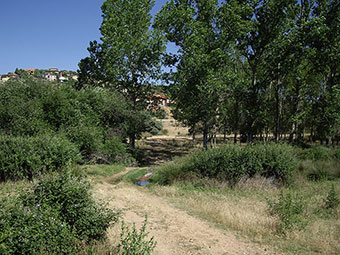
Hiking trails
In Mesones there are several paths to walk, but one “official” route stands out:
RCGU-28: MESONES. THE ARROYO DE LA GALGA
DATA SHEET
Start and end of route: Mesones
Type of route: Circular
Distance: 5,300 kms.
Minimum height: 767 meters
Maximum height: 863 meters
Walking time: 2 hours
Difficulty of the route: Low, can be done as a family
Material:
Walking boots, warm clothing in winter, plenty of water, sun hat.
Recommendations: It is worth taking binoculars to observe the birds along the La Galga stream and in the Mesones Navajo, which are often used as a watering hole (the stream area is the best area to observe different songbirds); We can also contemplate the landscapes of the mountains of the Central System in part of the route.
Situation:
Mesones is located in the countryside of Henares, near the Central System highland. The urban nucleus sits at the bottom of the valley excavated by the La Galga stream, which rises a few kilometers higher.
Description of the route:
In the Plaza Mayor there is a panel with all the information about the route. Throughout it we will find various panels for better orientation.
We start from the Plaza Mayor de Mesones next to the Town Hall to continue along the road that leads to El Casar. We will always walk to the left and perfectly signposted.
After about two hundred meters we turn left to enter the Nuevo Mesones urbanization and we begin a long slope along El Roble street. When we go about 900 meters, the street begins to flatten and after a kilometer it reaches a junction with Calle El Enebro, here we turn right to continue along this same street.
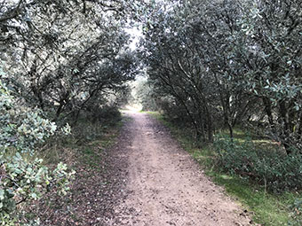
Shortly after, our route leaves the urbanization walking through one of the accesses to it, always with caution, although it has little traffic. About 400 meters after having left the urbanization, to the left there is a small park with some holm oaks and a bench; in this place we can see an information panel about the Navajo of Mesones, which is in front of us in direction E. We recommend approaching the Navajo.
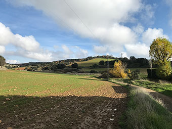
Advancing along the road we have on the right the holm oaks and the depression of Arroyo de La Galga and on our left the cultivated fields that cover “El Llano de la Mesa”. In the Llano it is possible to spot steppe birds such as the great bustard, the imperial eagle, since the whole area is a range area for this, as well as Montagu’s harriers and pale harriers, golden eagles and griffon vultures.
We arrive at the GU-1057 road, we will cross it to the right to continue for about two hundred meters along a dirt road and that we quickly abandon it by another lane that leaves us to the right in the O direction.
Continuing along the lane, we leave different firebreaks on our right that descend vertically towards the stream. These firebreaks present important water erosion processes.
We will pass by a shed, artificially dug, and which has water for a good part of the year, when it is stored in the clay substrate of the “Raña de El Casar”. Here we find another information panel.
At 900 meters from the road and near the nava, we find a lane to the right that is also another firewall. We will descend along it towards the La Galga stream. The panoramic view is of great beauty, being able to appreciate the holm oak grove and the meadows on both banks of the stream, and the landscape of gullies that originate from soil erosion.
Going down the firebreak, you can see the entire valley: Las Colinas-El Chaparral to the south, the “Casas del Rábido” farm to our left and to the north the Lago del Jaral urbanization and the town of Mesones. We cross the La Galga stream and come to a new track, which is actually a ravine. We recommend doing a variant, as the panel indicates, and continuing to the left for about 900 meters until reaching the treatment plant; from here, heading SE and E, we can see two large gullies.
Back on the track we return to Mesones. The riverside forest landscape follows the course of the Arroyo La Galga and it is not uncommon to find flocks of sheep, as we walk through a ravine.
In Mesones, again in the Plaza del Ayuntamiento, we conclude this hiking route.
WAY OF VALDENUÑO:
From Los Cipreses de Mesones, leaving the bullring on the right hand side, we reach the roundabout at the end of the street and continue along the path that comes out to the right. This is where the Camino de Valdenuño begins, which, crossing a lush area of trees first and bordering extensive fields of cultivation later, takes us directly to the nearby town of Valdeluño.
Be careful, because it is easy to lose your way, since it is not always well defined.
MIRASOL STREET:
In this case, taking the path to the left of the roundabout at the end of Mirasol street, you access a very pleasant dirt path to walk, although not in the height of summer, because shade is scarce. When crossing the Retamar stream, the path forks. Continuing on the left, you will soon reach a point from which you cannot continue and if, on the contrary, you opt for the right side, you will reach the Voran Canine Center.
Excursion to the 'black villages' of Guadalajara
The Black Towns route begins in Tamajón, about 40 minutes by car from Mesones. This route is highly recommended to spend a full day from first thing in the morning. Its name is due to the color of the houses that make up its towns, since they have been built, for the most part, with black slate. This material, very rich in the area, was used for both the roofs and walls of the houses, with the result being a dark house that gains in beauty when the stone is wet. On this tour of the black towns of Guadalajara you can find a palace, several churches, hermitages, examples of black architecture, waterfalls, oak groves and the beautiful place “the enchanted city.”
In Tamajón, the route of the black towns forks in two directions for 111 km, surrounding the Pico del Ocejón. The route is made up of nine small towns:
- Tamajón: See the enchanted city, the Palace of Mendoza, its 13th century church of Ntra. Sra. De la Asunción and the Hermitage of Ntra. Sra. De los Enebrales.
- Campillejo: It is recommended to wander around it. Of great ethnographic value. Pending declaration by UNESCO as a World Heritage Site.
- El Espinar: Views over the Jarama River
- Roblelacasa: See the Aljibe Waterfall
- El Cardoso de la Sierra: The church of Santiago Ápostol, the Hermitage of San Roque, from the 19th century, the fountain in the square, the fountain of La Mailla, the forge or shoe rack, the mill and the Town Hall.
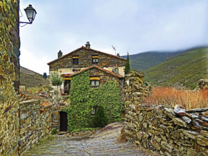
- Campillo de Ranas: A highly demanded place for weddings due to its location in the landscape, the Jaramilla valley, ideal for strolling through its streets, with many charming corners.
- Majaelrayo: Its fountains dating from the 18th century and the Robledo baths, known for their curative water, stand out. It has a museum with the history of the place.
- Almiruete and Palancares: These two small towns that are part of the route of the black towns are a quiet stop to wander through their streets. They are surrounded by forests with holm oaks, poplars and strawberry trees.
- Valverde de los Arroyos: A town with true charm where the black architecture changes a little color due to the use of quartzite. One of the great attractions of Valverde de los Arroyos is the Chorrera Waterfall, which is 120 meters high.
More information: https://rutapueblosnegros.com/
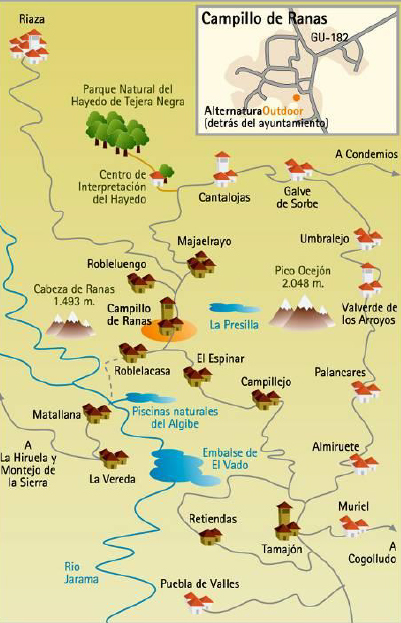
Map of the route
Excursion to Patones de Arriba
In Patones it is possible to enjoy a village hidden between mountains, landscapes created by water, an ancient Roman city, orchards irrigated by the waters of a centenary canal, numerous hydraulic infrastructures, rocks created on the seabed and a surprising nature.
Patones de Arriba is one of the best and most representative examples of black slate architecture, being a unique example in the Community of Madrid, which has made it worthy of being declared in 1999 an Asset of Cultural Interest in the Category of Historic Site, for its great ethnographic and environmental value.
The town is half an hour from Mesones. It is not possible to park inside the urban area, so it is convenient to go early to park in the small parking lot on the outskirts.
More information: https://turismo.patones.net/
Excursion to the Atazar Reservoir
A little more than 30 km north of Mesones, about 40 minutes by car, you reach the Atazar Reservoir, the one with the highest flow in the entire Community of Madrid and whose waters come mainly from the Jóbalo and Lozoya streams.
Our recommendation is to go through Valdepiélagos, take the detour towards Uceda and then the M-134, which passes through the Pontón de la Oliva, an old dam built in 1857, equipped with a hiking area with views and climbing routes.
Continuing towards the Atazar dam there are several viewpoints close to the M-134 road. From them you can enjoy a spectacular panoramic view of both the dam and the mountains that surround it. In addition, in the reservoir there are numerous sports activities such as sailing, windsurfing, rowing or canoeing and you can enjoy wonderful sunsets.
Excursion to the Hayedo de Tejera Negra
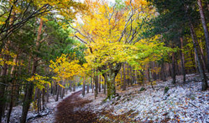
In July 2017, the UNESCO World Heritage Committee agreed to include the Hayedo de Tejera Negra, located in the Province of Guadalajara, on its World Heritage list, after being recognized as a representative forest of the European continent, one of the the southernmost beech forests in Europe.
El Hayedo de Tejera Negra occupies an area of 1,641 hectares, and is located in the northwestern corner of the Province of Guadalajara, forming part of the Massif de Ayllón, at the eastern end of the Central System. It is part of the Sierra Norte de Guadalajara Natural Park, and is classified as a Special Protection Zone.
The beech forest has a fairytale atmosphere due to its colors, the moss on its floors and its silences. In addition, Pyrenean oaks, scots pines, yews, holly and birch trees grow. The popular Boletus Edulis grows on its soil in autumn, and its skies are crossed by the golden eagle, over roe deer, foxes and wild boar.
Walking and traversing the trails of this dream place is a unique and unrepeatable experience.
More information:
http://en.www.turismocastillalamancha.es/naturaleza/hayedo-de-tejera-negra-53172/descripcion/
https://siempredepaso.es/visitar-hayedo-de-tejera-negra-guadalajara
http://turismoenguadalajara.es/reportajes/hayedo-tejera-negra-patrimonio-unesco/
Visit to the Río Dulce Cliff Natural Park
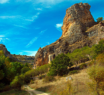
The Río Dulce (Sweet River) cliff is one of the most unique natural environments in central Spain. It is an ideal place to enjoy in spring or autumn, when the landscape stands out more and the contrast of colors is obvious. There are three towns that shelter the Río Dulce ravine and that together with a forest of holm oaks where junipers, junipers, poplars, willows and even ash trees emerge give the Río Dulce a unique shape. The ravine is covered from an accessible path, suitable for everyone. There is even a 1.5km route for the blind from the town of La Cabrera, so the Río Dulce cliff becomes a very accessible environment even for families and children.
It is easy to see griffon vultures, hawks and even golden eagles in the ravine. This place was one of Félix Rodríguez de la Fuente’s favorites. There, the famous naturalist recorded several episodes of the most famous TVE series, “El Hombre y la Tierra”, a series that aimed to show the nature and fauna of Spain.
In the Barranco del Río Dulce it is possible to do several hiking trails.
More information:
https://www.viajaporlibre.com/espana/castilla-la-mancha/barranco-del-rio-dulce
http://en.www.turismocastillalamancha.es/naturaleza/parque-natural-barranco-del-rio-dulce-53272/descripcion/
Visit to Sigüenza
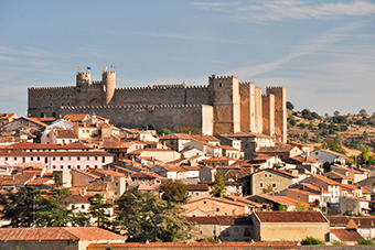
Sigüenza is a beautiful medieval city with labyrinthine streets that intersect, a magnificent Romanesque cathedral and an impressive medieval castle converted into a National Parador. It is located next to the Río Dulce Cliff Natural Park and is worth visiting and getting lost in its historic streets.
More información: http://www.turismocastillalamancha.es/patrimonio/siguenza-82231/descripcion/
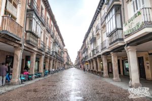
Visit to Alcalá de Henares
A highly recommended option from Mesones is to go 40 kilometers along the M-119. You are 45 minutes from Alcalá de Henares. Its name means “castle on the river Henares”, for which reason a castle on water waves that simulate the river Henares appears on the shield. Its foundation dates back to Celtiberian times (Ikesankom Kombouto or Iplacea), but it will be with the arrival of the Romans that a remarkable city called Complutum will be formed. Various cultures have passed through the city, of which three came to coexist simultaneously.
It was declared a World Heritage City by Unesco in 1998. Thanks to the historic site and the University Rectorate, it is one of the nine cities in Spain that Unesco has classified as unique. It is famous for its University, built thanks to Cardinal Cisneros on April 13, 1499, but after languishing during the 18th century, through the Royal Order of the Regent Queen of October 29, 1836, its abolition was decreed in Alcalá and transferred to Madrid, where it was renamed the Central University. It emerged with its current status in 1977, when the phenomenon of university decentralization occurred and it became its own university, which turned it once again into a university city.
You can get lost in its cobbled streets, eat in one of its many bars / restaurants and visit a multitude of historical sites that are well worth it.
More information: https://www.turismoalcala.es
Kayaking down the Jarama river
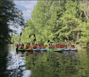
Kayaking down the Jarama River (2 hours), ideal for children and adults. Surrounded by spectacular natural surroundings, you’ll enjoy a fun and safe experience. Organized by PlanetSport Multiaventura, in Talamanca del Jarama.
They also rent canoes so you can explore at your own pace.
More information: https://www.planetsport.es/
Contact information:
C/Huertas, 13, Talamanca de Jarama 28160 (Madrid)
[email protected]
(+34) 699 361 161
Karting/paintball
- Karting Madrid Ángel Burgueño: Karts Circuit at the A-1 motorway, exit 47, Km 45.800 (28723 Pedrezuela)
More information: https://www.kartingangelburgueno.com - Karting Cabanillas: Go-kart and paintball circuit in Cabanillas, three-quarters of an hour along the N320 road.
More information: https://kartingcabanillas.com - Adrenalicia Tematic Paintball: Paintball field in Algete, half an hour from Mesones.
More information: https://www.tematicpaintballmadrid.com
Quad and buggy routes
Just half an hour from Mesones, TRQM offers guided quad and buggy routes. A different experience.
More information: http://www.trqm.es
Horse riding
Near Mesones there are several equestrian centers that offer the possibility of horse riding in the area:
- Centro Hípico Galiara
Carretera C 100 a Madrid, 7, 28160 Talamanca de Jarama, Madrid
Tel.: +34 622 23 83 74
Web: http://hipicagaliara.com - Club hípico Aires de Jarama
Cañada del Barco Viejo, 28140 Fuente el Saz de Jarama, Madrid
Tel.: +34 630 74 00 30
Web: https://www.airesdejarama.com/ - Club hípico Lira Cubero
Cañada del Barco Viejo, 28140 Fuente el Saz de Jarama, Madrid
Tel.: +34 637 43 82 46
Web: https://www.clubhipicoliracubero.es/es/ - Hípica Nuevo Valbueno
N-320, 296, 19171 Cabanillas del Campo, Guadalajara
Tel: +34 629 25 20 92
Web: https://www.hipicanuevovalbueno.com
Paragliding and paramotor flights
A 40-minute drive from Mesones is the Muela area, an emblematic mountain of free flight in Spain. It is located in a town called Alarilla, in the region of La Alcarria, Guadalajara. In this area there are many companies that offer paragliding and powered paragliding (paramotor) flights as unforgettable experiences for the most adventurous. Here we indicate some of them, in case you want to encourage yourself…:
- https://dparapente.com
- https://vuelalamuela.com/
- https://madparapente.com/donde-volamos/alarilla-la-muela-guadalajara/
- https://www.atrapalo.com/actividades/sobrevuela-guadalajara-en-parapente-y-descubre-la-muela-de-alarilla_e4864850/
- https://everent.es/actividades/parapente-en-guadalajara-vuelos-biplaza-cerca-de-madrid/
Sports
Fronton, basketball and football:
Behind the bullring are the municipal sports facilities. They are freely accessible, with the only condition of “asking for the turn” if someone is using them.
Paddle and tennis:
- Public courts at El Casar (also fronton and football)
Reservations phone: +34 616 074 267
More information: https://elcasar.es/alquiles-de-pistas/
- El Coto Sports Center
Avenida de Bruselas s/n. Urb. El Coto (El Casar)
Tel. +34 639 982 921
More information: https://www.elcotopadelytenis.com
Golf:
- Golf club Retamares
Urbanización El Miraval, c/ Aldebarán, 71, 28130 Alalpardo (Madrid)
More information: http://www.golfretamares.com/es/index.php - Real Club La Moraleja 3 and 4
Carretera Fuente el Saz, (M 111) km 16,500 – Finca Soto de Mozanaque, 28110 Algete (Madrid)
More information: https://www.realclublamoraleja.com - Making golf academy
Ctra. de Algete a Alalpardo, KM, 2300, 28130 Madrid
More information: http://makinggolfacademy.com

